Wednesday, August 14, 2013

Milford Sound - one of the top ten scenic drives in the world

We'd read in the Central Otago Times that the road to Milford Sound is currently on the cover of National Geographic as one of the Top Ten Scenic Drives in the world.  But even that designation couldn't really prepare us for the beauty and glory of this road.  


Weather cooperated very nicely with us today (as I sit here blogging in my cozy hotel room, it's pouring outside, but it was mostly sunny earlier today).  We headed out from Te Anau at 8am for our 11am cruise, surrounded by beautiful mountain ranges all featuring a new light dusting of snow on their higher elevations.  We passed the usual farmland (hello sheep) as we started getting closer and closer to two huge mountain ranges.  Turns out that the road we take to Milford Sound drives right between those two ranges.  Yippee for us!  Also yippee for us - the Eglinton River has carved out a great valley between the two rivers, giving us gorgeous views and also allowing us to take a not-as-curvy-as-expected path towards the Homer Tunnel.


After several stops for photos, we got closer to the Homer Tunnel region.  This area is very prone to avalanches and in fact was closed a few weeks earlier in the winter for more than a week so they could shore up a section near it to protect it from avalanches and/or rock slides.  Due to the overnight snow in the higher elevations, we were told we had to carry snow chains with us and to expect snow near the Homer Tunnel.  Definitely an inch or two of snow on the ground near the tunnel, but the road crews had done a great job clearing the road and putting down some traction.  

Tunnel ahead!


The tunnel itself is an engineering marvel, boring straight through the middle of a huge mountain (it took more than 20 years to complete, mostly due to unexpectedly hitting water as they dug and having to pump it out continuously for the 20 years of construction).  It's 1 lane though can snugly handle two cars going in opposite directions (but not two buses).  It's also roughly hewn and downhill with a fairly steep gradient.  We were happy once we cleared the tunnel and got through the snaking, snow-covered road on the other side, as we were told it was the toughest part of our journey to the Sounds.

On the flip side of the tunnel - that's the mountain we just went through
 About 20km later, we arrived happily at Milford Sound, our camera chips already loaded with gorgeous pics from the drive and ready for more from the cruise.  The Milford Sound is actually a fjord (one of the leading fjords in the Fjordland area on the southern part of the South Island).  On the first 1/3 of our nearly 2 hour scenic boat tour, Beth and I were the only ones on the top outside deck enjoying the views.  It wasn't that chilly, the sun was out for much of it, and the scenery was gorgeous.  But the all-you-can-eat buffet on the bottom level was apparently too much of a lure for everyone else on the ship, so we had own own private tour for the first 30-40 minutes.  Sweet.  After they finished eating, we did end up with many visitors on the top deck with us, but no one stayed the entire time like we did. 
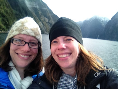
Selfie since we were the only ones on the top deck of the ship
Most of the boat were full of Japanese and Korean tourists (we'd passed their bus en route to Milford, with the Pacific Adventures or something similar emblazoned on the side).  Beth and I were highly entertained by many of these passengers fulfilling the Asian stereotype of taking many, many photos, mostly of themselves in funny poses.  We got to see several couples re-enacting the Leo and Kate scene on the front of the boat from Titantic, and I think every other person on the boat besides us took a picture with the bell on the front of the boat on the first level.  I'm not sure how much they paid attention to the scenery around us, but if they were too focused on pics of themselves and not enough of their gorgeous surroundings, they're definitely the ones who missed out.  Hundreds of waterfalls, sheer rock formations (including copper, quartz and iron), Mitre Peak, and even some baby seals greeted us as we passed through the Sound. 

Kate and Leo - luckily without us hitting an iceberg

Fjord views - heading out the Tasman Sea

This waterfall is the height of a 50 story building.  Wow.
As we headed back into port, we were greeted by a perfect rainbow.  What a great Kiwi welcome!  


After our cruise ended, we headed back towards Te Anau, enjoying the amazing views on the drive back.  We stopped at one of the hiking trails to take a quick jaunt down to the river and to see some waterfalls close up, but we had to quickly abort the mission when a very aggressive kea hopped on top of our car and started eating the rubber on it.   Those keas are very, very cheeky birds, and they are not afraid of humans (apparently they love rubber - they'd go after windshield wipers, rubber edging, tires, etc).  For the sake of not getting fined by our rental car company for the rubber repair, we opted to chase the kea off the car and head on down the road.  We later saw another kea attacking cars/campervans as we were waiting for the Homer Tunnel stoplight to give us the go-ahead to head through.  No wonder there are signs all over the park warning people not to feed the keas.  No one wants a more aggressive bird than they already are!


All in all, yet another gorgeous, amazing place we've gotten to visit in New Zealand.  This country defies words.

We're now approaching the end of the trip, heading back to Queenstown tomorrow just in time for the Winter Games Opening Ceremonies (it's an X-games type event, and even the "Flying Tomato" Shaun White will be in town - we'll keep an eye out for him!).  A crowded Queenstown will be quite a change from sleepy Te Anau where we were the only ones eating at the restaurant we went to tonight (last night we were one of two tables until 4 more tables filled up right before we left).  Since we're staying at the same hotel we stayed at last time which wanted to charge us $15 for 2 hours of internet usage (up to 100MB), I know our internet access will not be great.  Luckily we found a cafe nearby that serves great churros and has free wifi, so I'll try to check in again from Queenstown.  If not, I'll do another post or two about our final days once I'm back in the US (or if the airports have free wifi).

Tuesday, August 13, 2013

Hello, Fjordland!

Started the morning off with beautiful views, churros and a gorgeous chai latte.  Hello, Queenstown!  


Erin left us yesterday to head back to Africa.  Beth and I left lovely Queenstown today after just a brief sojourn there (don't worry - we'll be back in a few days).  We endured another disgustingly scenic drive to  Te Anau, our starting point to explore Milford Sound. 

First stop: glow worms cave.  Took a half hour boat ride across Lake Te Anau, NZ's second largest lake, and then entered an underground cave system to learn about these glow worms.  The cave journey culminated in a very disconcerting boat ride into a grotto to see hundreds (thousands?) of glow worms on the cave ceiling and walls, all in the pitch black and complete silence.  It was cool but very strange.


Since we're not allowed to take any pics in the cave, here's a link to what the glow worms look like for those who are curious.

Fjordland is known for its rainy weather, and today is no exception.  The day actually started off fairly sunny but by the time of our tour, it was gray and drizzling.  Perfect time to catch up on a little wifi availability at our B&B before heading out to dinner.  Te Anau is a very sleepy little town in the winter.  Tomorrow's trip to Milford Sound will perhaps also be rainy, but it's supposedly best seen in the rain (more atmospheric).  We shall see!

Watch out, sea! I'm coming for your fish and other sea life...

Blue Cod poached with ginger, lemongrass and star anise

So I've learned on this trip that I really like NZ Blue Cod - and that I really, really like Bluff Oysters.  Those suckers are hard to find (only available down south on the South Island for about 2 months of the year) and really expensive, but they may have been the best oysters I've ever eaten.  They're sand oysters instead of rock oysters, whatever that means.  I think it means they are extra delicious.

Bluff Oysters

Blue cod - fish and chips style


Monday, August 12, 2013

Jetboating is awesome - until it isn't...

Inspired by the jet boating in Amazing Race this season (and the omnipresent jet boating opportunities in NZ), Beth, Erin and I headed out on Lake Wananka and a nearby river this morning to experience this phenomenon.  I should have been concerned when our driver asked if any of us get motion sick.  Oh boy.

The "before" shot - there was no "after" shot thank goodness...


View from Lake Wanaka (when we stopped for photos).  This is the mountain range that includes Treble Cone ski resort, which we skied the previous day.

Jetboats can go amazingly fast in very small amounts of water (only need ~3 in).  That was awesome.  What I didn't expect was the quick banking turns and 360 spins (they didn't show that on Amazing Race).  It was fun and I only felt a little motion sick - until just before we got back to the dock and our driver did two quick, fast spins in alternating directions. You couldn't get me off that boat fast enough after that.  Luckily, I didn't actually puke but it was close...  
River views (when we were still going slowly - no way we could take pics when going fast - had to hold on for dear life)

So thumbs up to go fast on rivers, over rapids, etc.  thumbs down to alternating quick spins.  Barfola.  Almost literally.


Sunday, August 11, 2013

Skiing in NZ (or, we're not in Kansas anymore, Toto)

We learned today that skiing in New Zealand is way different than skiing in the US.  It's in fact slightly terrifying.  First, you have to conquer a 7km dirt road that winds its way WAY up a steep mountain - with no guardrails, steep drop offs, and what seems like only 1 lane (but is in fact a two lane road).  Sheep also wander onto the road without warning.  We all agreed that it was one of the most terrifying roads we've ever been on.  Erin drove it like a rock star (and keep in mind, we're driving on the wrong side of the road here), but we all had sweaty palms and fogged up the windows by the end with our panic.


Then we get to the base of the ski mountain, only to see lots and lots and lots of bare ground.  I mean, lots.  Parking lot is a mud pit.  Our ski rental guy the day before had warned us about this lack of snow and had told us to head to the other lift for better snow (higher elevation).  Oh, did i mention there's only 2 lifts at this ski resort? And it has the largest ski-able area of any ski resort on the South Island?  Oh my.  We're really not in Kansas anymore (or more aptly, Colorado).


Under very cloudy skies, we headed up the first lift, and then took another incredibly terrifying and treacherous ski road over to the other lift.  The runs that this cat trail were above seemed to head straight down the (very steep) mountain.  We all hugged the far side of the run and stayed as far away from the edge as possible.  We decided that since there aren't any trees anywhere on the mountain, these runs seem so much more treacherous.  In the US, if we were to lose our edges and fall, a tree would most likely stop us.  Here, we'd keep tumbling and tumbling and tumbling down the (did I mention steep) hill, until maybe a sharp rock stopped us.  Ouch.


We finally made it over to other ski lift, and there indeed was better snow and at times even decent visibility (at other times, we were literally skiing in a cloud).  We ran most of our day over in that section of the mountain, re-running the 3 groomed trails again and again (the ungroomed trails had major snow issues and with the cloudy skies were incredibly hard to see - with either more snow or better visibility, we would have been brave enough to try some of them, but that wasn't to be).  The bottom of the runs were pretty icy (and later slushy) but the top of them were pretty sweet.


Possibly the best part of skiing was the view the entire time.  Every direction you looked were more gorgeous mountains, even under the cloudy skies.  Wow, and wow, and wow again. 

When we headed down the mountain in the early afternoon as the clouds took over the top again and the winds picked up, we were greeted on the lower part of the mountain by crazy corn snow (wet, sloppy snow), as well as a lot of bare patches.  Beth and I decided we were done for the day around 1:30, though Erin made it out for a few more runs after that. Not shockingly, I had boot issues with my rental boots (I always have boot issues, as my family will attest), so I needed to get the rental boots off ASAP at that point.

We're all glad we skied New Zealand (esp since the first place I ever skied was somewhere in NZ when I was 11 - thanks Dad!), but we all agree that there's no place like home...

(Another skier on one of our lift rides told us he'd skied another resort near here the day before and it literally rained on him the entire time; by the end of the day it was pouring buckets and everyone was soaked - yuck.  On a more positive note about NZ ski resorts, there was a youth race at Treble Cone that day, and it seemed like people came from Europe and other distant places to ski there, so it obviously was well-regarded enough to warrant a long trip there).

8/13/13 update: back in the land of free wifi so added some pics!

Saturday, August 10, 2013

View of views

Since it's winter here in NZ, we haven't had to pre-book anything (tours, reservations for dinner, etc) - but that strategy failed on us this morning when we were shut out of the tour we wanted to take hiking onto Fox Glacier.  Instead, we headed out to Lake Matheson for what is promised as the "view of views" of all of New Zealand.  Thanks to amazing blue skies and clear weather, that promise did not disappoint.  We not only enjoyed stunning vistas of Mt. Cook and Mt. Tasman (and their reflection in the lake) but also got a unexpectedly interesting 90 minute walk through a temperate rain forest.  Two thumbs way up.


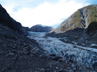
We then headed to Fox Glacier and did our own walk to the terminal face (no walking ON the glacier itself without a guide, but we could get pretty close).  The glacier itself was pretty cool but having seen so many larger and more impressive ones in Alaska, it was slightly underwhelming.  If we'd sprung for the $400 pp heli-hike option where we'd get dropped at the top of the glacier and hiked for a few hours, it may have been more impressive, but we couldn't justify the $1200 cost for the three of us.  Maybe next time...


Ultimately, we were happy with how the day at the glaciers turned out, despite the initial disappointment of missing out on the tour.

The rest of the day was spent driving from Fox Glacier down the West Coast to Wanaka, over the Haast pass.  Our great weather continued to follow us, and we were rewarded with absolutely amazing views the entire way.  It seemed like every time we turned a corner, another vista appeared that took our breath away.  At one point Erin got mad at New Zealand for being so beautiful - it just isn't fair.  Hee hee.


8/13/13 update: photos added!

Friday, August 9, 2013

Driving fun!

We knew today would be our biggest driving day of the trip, heading from the northeast part of the South Island (Blenheim) to the southwest coast (Franz Josef glacier).  Luckily, the drive went smoothly, crossing the Southern Alps was a piece of cake (followed a canyon through them), and the scenery was spectacular throughout.  I only got a tiny bit car sick along the windy coastal roads (a nap got me through the worst of it).

The area from Blenheim to the Southern Alps was a gorgeous valley, full of vineyards, sheep and cows, surrounded by beautiful mountains.  We had mostly sunny weather, and then when some rain was falling in the distance, we came across the most perfect rainbow - complete with a kiwi crossing sign (the only kiwi crossing sign we've seen the entire trip, mind you).  New Zealand continues to impress with its scenery - and it's amazing timing with things like rainbows.


The Buller Gorge through the Alps was lush and scenic, with us following the Buller River from a small braided river to a roaring beast as it neared the Tasman Sea.  Then the West Coast, with its fierce waves, rock formations, and amazing cliffs did not disappoint.  The highlight of the West Coast scenery was stopping at Pancake Rocks and Blowholes (hee hee - blowholes), which photos can just capture a small part of the uniqueness of these rocks and the fury of the sea as it crashed ashore.


We rewarded ourselves when we finally arrived at Franz Josef Glacier with a nice soak in their Glacier Hot Pools.  Not quite as natural as the hot springs in Rotorua but still a nice way to spend an hour or so after a long drive.  Franz Josef village itself is 2 blocks long by 1 block deep, so it's a small little town whose express purpose is to support visitors to the nearby glacier.  We found ourselves a nice pizza joint in town with Friday night specials, added a bottle of Pinot Noir, and settled in for the night at our motel (side note: NZ is teeming with motels; they have not gone out of fashion here, though backpackers, hotels, and "holiday parks" (RV parks) are also plentiful).

(we're quite limited in our internet here at this motel in Wanaka where I'm catching up on a few days of blog posts, so I'll have to go back and add more pics later - sorry!)

8/13/13: photos added - thanks free wifi!